Highway 93 plan sets goals for future of corridor

Aiming for improved pedestrian and vehicle routes, while creating a more aesthetically pleasing area, the city’s Highway 93 South Corridor Plan sets out future goals for the south entrance to Whitefish.
The draft corridor plan was recently released for public review. The Planning Board is expected to vote on the plan at its August meeting and then forward it to City Council this fall.
The long-range plan looks at how the corridor will grow over the next 10 years in terms of land use, transportation, environment and open space. The plan includes goals, objectives and implementation items for the corridor.
The boundary for the plan extends from the edges of downtown at Sixth Street on Baker Avenue and Spokane Avenue to 2 miles south of Montana 40.
“The Highway 93 South Corridor Plan envisions a corridor representative of the Whitefish character with abundant green spaces dominated by views of surrounding mountain ranges and the Whitefish River,” the executive summary of the plan says. “It should be a walkable and bikeable corridor with a variety of uses and services available.”
Long Range Planner Hilary Lindh said the plan was developed with input from the Highway 93 South plan committee and from open houses held on the plan. The themes that came from the comments shaped the vision, goals and objectives found in the plan, she noted.
“The corridor is an entrance to town that should represent what people who live here think of as the Whitefish character,” one of those comments said.
The plan divides the corridor into three distinct segments with a vision for each segment and setting goals to achieve that vision. For each segment, the plan looks at land use, transportation, and environment and open space as it applies to each.
Segment A is the northern end between East Sixth Street and the Whitefish River. It’s a mix of residential and residential structures converted into commercial uses.
The vision set in the plan is that this segment serves as a gateway to downtown Whitefish and a transition from the highway commercial uses to the residential and light commercial in the downtown area. Buildings in the section should remain small-scale and the urban tree canopy should be maintained and expanded where lacking. Public green spaces and recreation areas should be abundant, the plan says.
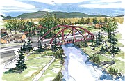
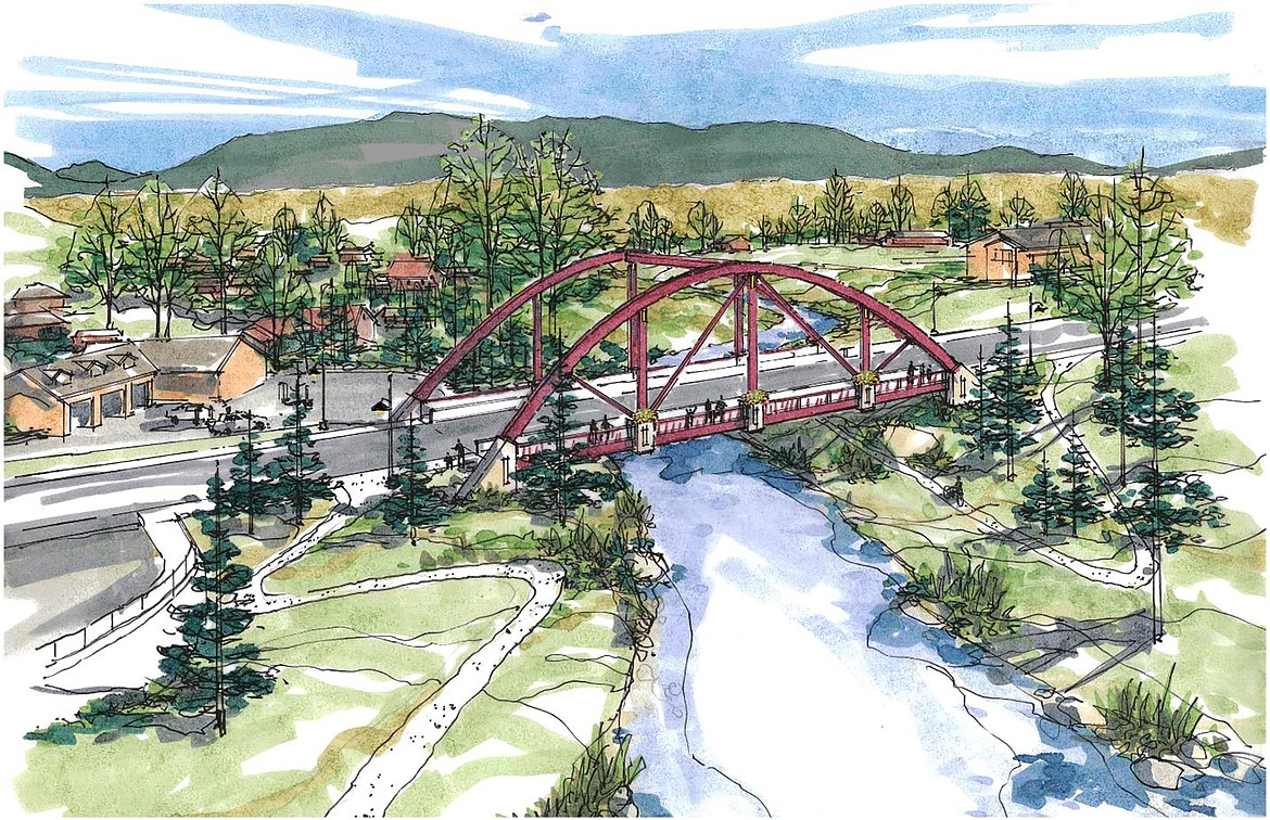
A large goal for the section is to replace the Whitefish River culverts with a bridge designed to serve as a transition or entrance to downtown. The bridge would also serve to allow for better pedestrian and bicycle access in the area.
“The bridge on Spokane Avenue would be safe for both vehicles and pedestrians,” Lindh said. “The vision is that it would provide for a view of the Whitefish River and also be a symbolic entry into downtown.”
Segment B extends from the Whitefish River to the city limits near Montana 40. The parcels in the section are relatively large with large commercial buildings, and some multi-family housing.
The vision for this segment is to maintain its character as a commercial corridor with a diversity of businesses.
Goals are to provide better public access to the river and increase public green space, and improve traffic flow in the area. Improving the visual character of the environment is also a goal with installing decorative street lighting and adding landscaping including street trees along sidewalks.
The plan calls for highway 93 in this segment to include a landscaped median in the center of the highway and a protected bike lane along the highway.
Lindh says the section now varies in how it looks with landscaping and the design of the sidewalks, and there are no dedicated bike lanes.
“The concept is for how it could change the look of the corridor,” she said. “By adding shade with boulevard trees and having the center median landscaped.”
Segment C extends from the city limits near Montana 40 south for about 1.5 miles to the southern edge of the city’s growth policy’s future land use map boundary. The segment has a combination of commercial uses lining the highway with residential uses behind, and agricultural uses farther south.
The goal for the segment would be to encourage Flathead County to enforce zoning and discourage land uses outside of the city limits that are inconsistent with the community’s vision for the area.
The city’s growth policy adopted in 2007 calls for the creation of corridor plans for all the major transportation corridors. Plans have been completed for Highway 93 West in 2015 and Wisconsin Avenue in 2018.
Work on the Highway 93 South plan began in 2018, but was delayed due to the COVID-19 pandemic.
The draft plan is available on the city’s website at www.cityofwhitefish.org under the planning and building long range plans page.